Kitanakagusuku Shisa Neighborhood

In the neighborhood that surrounds Nakagusuku-jo (one of the UNESCO gusuku heritage sites), the residents are known for taking great care to beautify the area. The flowers are always well tended after, while shisa シーサー and other pottery/sculptures can be found dotted all over. Now, to be honest, some of these sculptures border on the bizarre (disembodied feet, for example), and it remains a mystery to me why they exist but it makes for an interesting experience. I won’t ruin the surprises in store for you if you decide to wander around this area, so I only put up a sampling of pictures below. There is much more fun to discover in this neighborhood.

While you walk through the area, there are a handful of small historical sites, some sacred wells and small parks, and most predominantly Nakamura House (a preserved old Ryukyu-style house that displays many features of traditional architecture).

We had an enjoyable afternoon just strolling around the area, just spotting all the various styles of shisa displayed and contemplating some of the designs of some of the sculptures. If you have time after visiting Nakagusuku-jo, I recommend enjoying a walk around the neighborhood, as well as a stop at Nakamura House (you get free tea and snack with your admission). Gosamaru’s tomb and a scenic lookout point are also in the area (read more here).


A Secret Lookout Point in Nakagusuku (& Gosamaru’s Tomb)

Recently I went to a “secret” lookout point while wandering around to find Lord Gosamaru’s tomb. It is not really a secret, but it is not well-known. Probably because it is actually under construction and not all the way opened yet… ?!

To explain: I was headed to Gosamaru’s grave and I noticed on the map a place called 台グスク dai-gusuku. When I looked for information before heading out, it mostly seemed that nothing much was there anymore except for some vegetation-covered walls, which were just places of worship surrounded by stones, and if you stood along the edge, you could see over the town and to the ocean. All of the pictures showed a simple narrow path and some overgrown grasses. It was perhaps part of the Nakagusku-jo residence in some capacity back in the Ryukyu Kingdom era; possibly as temporary quarters for Lord Gosamaru until he moved into Nakasuguku-jo from Zakimi-jo or maybe where his brother lived, no one is certain from the information I gathered from some Japanese websites.

So, as I ascended the hill from after visiting Gosamaru’s tomb (just around the corner), I decided to take the small path that led to this mystery place. It is closed off to cars as there is a chain across the path to block cars, but it is easy to walk around and there are no signs saying “entrance prohibited” 「入場禁止」 as it is a public walking path.  I walked along the worn-down path for a bit, until I saw a brand new structure… a ramp, some stairs, all leading to an observation platform! This was indeed a surprise. The bottom ramp was taped off (I assume because the side railings were not installed in some areas), so I didn’t push my luck and enter it. Instead I kept walking along the path that was parallel to the ramp and stairs. At the top of the path, there was a clearing and you could overlook the town… I could see over towards my house! Since there was no tape blocking off the very top platform, I went ahead and took a peek standing on the new platform, since the view was a little bit better with the extra few feet in height. Amazing! What a view, and well worth the short walk.

Hopefully they “officially” open this viewing platform soon. The structure looked almost complete and was structurally sound (just use common sense). It is fine to enter the path and walk up to the observation area since it is public. However, please be considerate and quiet because there are family graves close by– we walked by 2 families cleaning the graves in the area just next to the path up.
**UPDATE: it is not opened yet, but they have paved the path walking up to it and most of the construction looks pretty complete. I expect this will be officially opened soon!

If you for some reason are interested in Ryukyu history, you can also walk to Gosamaru’s tomb 護佐丸の墓 which is a little further down from the main road. It is actually right below you when you stand on dai-gusuku, but you need to go back out to the road, around the corner, and there is a path with some stairs leading up. Gosamaru chose a pretty nice spot for his tomb. Overall, it is not a terribly interesting historical site, but I figured as a town resident I ought to see it at least once.


Instructions: park at Nakagusuku-jo (castle ruins): https://goo.gl/maps/z2h7nN8gR1B2
then walk to here: https://goo.gl/maps/3H76M5M26rx

Gosamaru’s Tomb, entrance here: https://goo.gl/maps/r7oY858hcek

Hanta Michi: ハンタ道

ハンタ hanta: Okinawan word for “cliff”

道 michi: road or path

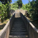
Hanta Michi is an old Ryukyu kingdom  road constructed around the Gusuku era (12th century). It runs from Shuri-jo to Katsuren-jo, passing through Kouchi-jo in Nishihara and Nakagusuku-jo in Nakagusuku Village. Several historical cultural properties remain along this path. It was lined with pine trees, cutting through hills and cliffs along the way.

Nowadays, the most accessible path of Hanta Michi is from the SanA on Rt 29 in Nakagusuku through to Nakagusuku-jo. Agai-tidabashi (bridge behind the SanA/Matsumoto Kiyoshi/Wafuutei) is the typical starting point. The trail ends at the border with Nakagusuku-jo– if you enter the premise you are supposed to pay the entrance fee at the end of the path marks the beginning of the castle ruins site. Another important thing to remember is that the gate to leave the castle site will be LOCKED if you are walking the trail during closed hours (one of my friends ran into trouble with this…), so if you plan on using the castle ruins as an exit, you must go when the premises is open for business.

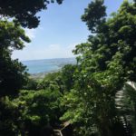
The path runs from urban to rural farms to forested area, with sweeping views over Nakagusuku Bay. Occasionally the path is overgrown, depending on the season. A good tip to remember is to look for the white-ish coral stone in the road along the path in most areas. It is not too long of a “hike” (walk?) to do the whole thing, maybe 5 km or so one-way, within 2 hours if you walk with a regular pace with a few stops for pictures or a snack.

If you plan your day well, you can make sure to take a break or end at one of the restaurants along the path (near the SanA end, not Nakagusuku-jo end). I recommend either LOHAS garden or Hanta Baru, both have good food and gorgeous views overlooking Nakagusuku Bay.

Click the imgur link for images:

https://imgur.com/a/NBoGF


Sites along the Hanta Michi:

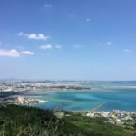
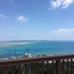
Agai-tidabashi Bridge 東太陽橋: Stunning views of Nakagusuku and the bay can be admired on sunny days. It is also a very popular spot to watch the first sunrise of the New Year and for full moon viewing.

161.8 Kouchi Jinchi 161.8高地陣地: Atop of the rocky mountain at an elevation of 160m in Kitauebaru area, the Japanese army built a high-ground position, known as 161.8 Kouchi Jinchi. A panoramic view, north to south, from Chatan town and Yomitan village to the Chinen peninsula is possible from this location.

Kishimakono-taki キシマコノ嶽: Okuma settlement began at the top of the mountain and people in the settlement still pray at this prayer ground today.

Arakaki Stone Bridge 新垣の石橋: This arched stone bridge is located over the stream near the fields of the Arakaki settlement. Similar types of stone bridges existed until just after WWII, however now there is only one remaining.

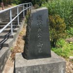
Prefectural Road Construction Monument 県道開削記念碑: This monument was built in commemoration of the opening of the Futenma-Yonabaru route (currently rt. 35) in October 1934.

Tunmaasu ツンマース: A pine tree is encircled by a low stonewall. Arakaki gusuku and Nakagusuku-jo are to the east and Ginowan is to the west.

Arakaki Gusuku 新垣グスク: The year for the construction of this castle is unknown, however, it is estimated to be early 14th century. Utaki (sacred place in Ryukyu culture) and shrine are seen inside the castle ruin grounds. These places are considered to be highly significant for the Arakaki settlement.

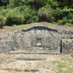
Uchibara-no-tun 内原の殿(ウチバラノトゥン): Hall of worship in Arakaki gusuku where people pray for health, longevity and to give thanks for good harvests.

Perry’s Banner Rock (Taachii Ishi) ペリーの旗立岩: It is said that Commodore Perry and his expedition team placed the American flag on top of this rock with a gun salute to commemorate their conquest during their expedition in Okinawa.

Giisu-no-tera ギイスのテラ: Prayer ground located south west of Nakagusuku-jo. The ancestor of Masu Shimabukuro of Soeshi village is said to have enshrined the spirit stone and began the ritual here.


SanA near the starting point of the Hanta Michi: https://goo.gl/maps/BXbBdYVTUh32

Nakagusuku-jo (end point): https://goo.gl/maps/GWHKmPFzMPv

Map Link (Google Maps): here


Extra information on MapItOkinawa: http://www.mapitokinawa.com/search?q=hanta

Morning Market: 朝の市場

In my village, on the 4th Sunday of the month there is a small community farmer and fish market. This mostly consists of the older folks with small farms or ones who like to make prepared foods. Sometimes there are special events (like free mozuku or free fish soup). I really like attending this and being able to support my neighbors. The first few times, we were often stared at, but now I think most of them expect to see the foreigner couple show up now.

Everything is really cheap, so we always go and buy some produce. It is an easy bike ride away, so we get our exercise at the same time.